
A Map Worth 12 Ducats
He came to trade horses. He left with the world.
The story
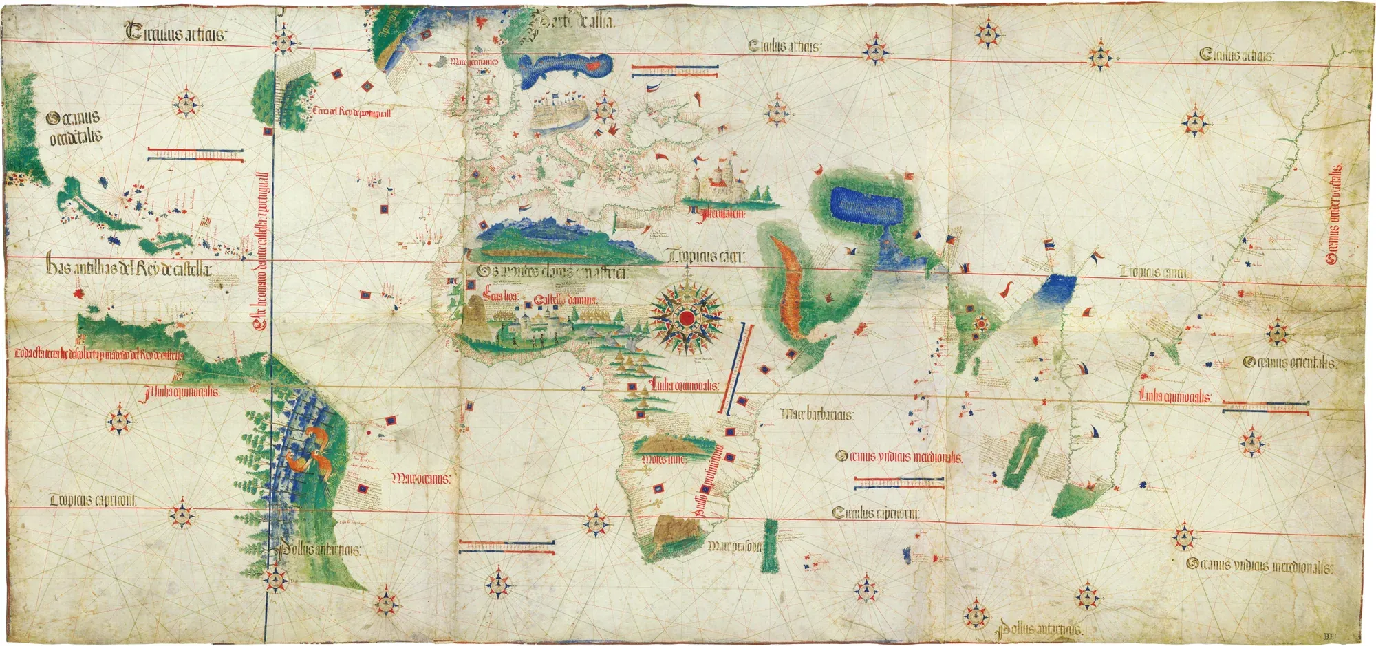
Alberto Cantino arrived in Lisbon in 1501 as a horse dealer. He was really a spy for the Duke of Ferrara, sent to learn what Portuguese captains found. Maps of the new routes were state secrets, yet for 12 gold ducats someone in Lisbon drew him a copy of the world: Brazil, Africa, the way to India. In 1502 he slipped it out of Portugal. In Genoa a mapmaker copied it, and from there its coastlines reached Waldseemüller's 1507 map, the one that gave America its name.
More
Context
Cantino's letters survive. In one, from 1501, he says he overheard Gaspar Corte-Real report to King Manuel on his voyage to Newfoundland. How he got the map is debated: a bribe to a Portuguese official, a purchase, or both. His price, according to the letters, was 12 gold ducats. The map is huge, over two metres wide, drawn on six sheets of parchment. It already shows the Tordesillas line, the coast of Brazil and the Portuguese fort of Elmina, and it is the earliest surviving chart to place parts of Africa, Brazil and India by latitude. The secret did not last. In 1504 King Manuel banned mapmakers from drawing the African coast beyond São Tomé, but copies were already travelling, and the Cantino map itself aged fast: Caverio's and Waldseemüller's maps soon overtook it. It sat in the library of Ferrara, then Modena. In 1859 a revolt ransacked the palace, and the library director found it in a pork butcher's shop, pasted on a screen. Today it is in Modena's Biblioteca Estense. A copy is kept in Lisbon's Museu de Marinha, in Belém.

Bridge to today
Maritime Museum
Museu de Marinha (cópia do mapa de Cantino)
The Museu de Marinha shows a copy of the Cantino map.
Praça do Império, Belém, LisboaBridge to today: Maritime Museum


Sources (8)· links checked on
- Wikipedia: Cantino planisphere
- National Geographic History: The Cantino Planisphere
- Museu de Marinha: Planisfério de Cantino (cópia)
- Gregory C. McIntosh: The Cantino Planisphere of 1502 (MEDEA)
- Biblioteca Estense / Historylab: Cantino planisphere
- BnF: Le planisphère de Caverio (dossier pédagogique)Accessed on
- Wagner (Ohio State): 1502 / Cantino PlanisphereAccessed on
- Northwest Cartographic: The Cantino PlanisphereAccessed on